In 1809, the word hike was “hyke,” which meant “to walk vigorously.” In the 1830s, the term originated as an English dialectical term and was used insultingly in East Anglia and London. Hiking is a moderately tricky activity that entails walking long distances on trails or paths. Being outside and walking can be a powerful stress reliever, leaving you feeling relaxed and refreshed even after a short walk. Nature has many positive effects on the body, including mental illness.
Hiking is not only good for cardiovascular health and muscle tone, but it can also help you sleep better. Hiking has been shown in studies to reduce stress levels, which aids in getting a good night’s sleep. So, here are the top 10 best places for hiking in Negeri Sembilan 2026 that you can bring your friends too.
Is Hiking Better Than Going To The Gym?
Hiking trains your body to function as intended; many muscles work in synergy, adapting to the situation as needed. Gyms frequently lack this by only exercising muscles in one direction, like taking the classic bicep curl.
How Should I Prepare For A Long Hike?
Strengthen your muscles by engaging in resistance training twice a week. Concentrate on strengthening your legs, glutes, and core muscles. Calf raises, squats, and lunges are excellent exercises for preparing your muscles for a hike.
10 Best Places For Hiking in Negeri Sembilan 2026
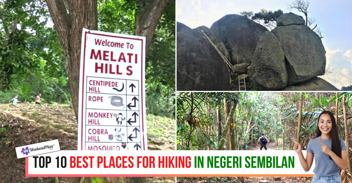
1. Melati Hill


Melati Hill, located in the Nilai area of Negeri Sembilan, is an ideal location for hiking. The location is about 5 kilometres from the Nilai city area, and it takes about 10 minutes to get there. Melati Hill is located approximately 350 metres above sea level. This hill has a straightforward and relaxing travel route and is appropriate for all climbers, particularly those new to climbing.
All four trailheads, including a tarred road, are located on Jalan BBN 11/4, but the main trailhead begins to the left of Na Du Gong Temple. Leads up to Centipede, Monkey, Cobra, and Mosquito Hills, each of which was designed with varying lengths and levels of difficulty. The main trail is relatively easy to hike until you reach Centipede Hill. It takes about 5 to 10 minutes to get there. When you get to Centipede Hill, you’ll see a signboard with directions to the next hills.
Address: Jln BBN 11/4, Bandar Baru Nilai, 71800 Nilai, Negeri Sembilan
Google Map: Navigate Now
Google Review: Here
2. Gunung Datuk


This mountain has several names and spellings. Gunung Dato’ or Datok is sometimes seen on road signs, while Gunung Rembau or Gunung Datuk Rembau appears on some maps. Gunung Datuk, at 855m, is slightly higher than Gunung Angsi (824m), but it is still dwarfed by Gunung Hantu Besar, Negeri Sembilan’s tallest peak (1,462m). The climb’s starting point is less than 80m, and the distance covered is 4.6km each way as the bird flies, implying that the distance is more significant.
On average, it takes about two hours to reach the summit and slightly less time to return. After a while, the path becomes less steep, and you may notice a cool breeze that provides welcome relief from the oppressive humidity. You will eventually arrive at an open area beneath the summit used as a campsite. From here, a series of steel ladders allow you to ascend the massive boulders that dominate the mountain’s peak.
Operating Hours: 24 hours
Address: Kota, Negeri Sembilan
Google Map: Navigate Now
Google Review: Here
3. Bukit Putus (Mount Angsi Trailhead)


This trail begins at Bukit Putus and leads to the summit of Mount Angsi. From the parking lot, cement steps lead up to the path. The path is difficult in some places because it is steep and may be muddy and slippery after rain. On this route, there are trail signs. The scenery along the journey is filled with tall and bulky trees with roots randomly popped onto the surface, making for a nice landscape view. Mount Angsi is enjoyable, but the 9-kilometre stretch is a significant muscle challenge for beginners or those not hiking.
If you’re lucky, you might see a group of monkeys or birds gossiping loudly on one of the high branches. Following that was an obstacle course made of wooden stumps and planks. The stumps and planks were a welcome distraction on the bone-dry trail, helping hikers navigate the mud-filled pools formed during the rainy season and minimising damage caused when new trails are forged.
Operating Hours: 24 hours
Address: Jalan Kuala Pilah, Seremban, Negeri Sembilan
Google Map: Navigate Now
Google Review: Here
4. Kepayang Hill Hiking Trails


Kepayang Hill is a small hill in Taman Bukit Kepayang, Seremban, Negeri Sembilan. Because there are several trails to choose from, including rock climbing, this hike can be easy, moderate, or difficult depending on which trail you take. Best of all, ropes are provided for extra support throughout the trail. Because this is a loop trail, you may need directions on the way back.
Kepayang Hill has some stunning views and fantastic photo spots at the peak, standing about 200 metres above sea level. Kepayang Hills is suitable for beginners and intermediates, with many trails to choose from. You can try rock climbing at the top of the mountain. Aside from that, you’ll get a 360-degree view of the range of mountains, Seremban and Seremban 2, as well as the North-South highway.
Operating Hours: 24 hours
Address: Jln Tmn Bkt Kepayang Besar 1, Taman Bukit Kepayang, 70200 Seremban, Negeri Sembilan
Google Map: Navigate Now
Google Review: Here
5. Bukit Taisho


Bukit Taisho, a series of interconnected hills in Negeri Sembilan, offers breathtaking views of the agricultural plains of Bahau. Hikers and exercise enthusiasts can enjoy sunrise and sunset views on a clear day, and when it rains overnight, they can gaze across a blanket of fluffy white clouds.
Initially, the trail descends through an oil palm plantation and passes a water point. There are several tracks with varying degrees of difficulty. According to the locals, Track 1 is the easiest, Track 2 is slightly more complicated, and Track 3 is the most difficult. Even though the path up Trek 3 was rocky and exposed, you will arrive at the ridge line in minutes and enjoy views of Bahau township along the way.
Address: 72100 Bahau, Negeri Sembilan
Google Map: Navigate Now
Google Review: Here
6. Bukit Senaling Hiking Trail


At only 394m, it is one of the most scenic mountains. Easy walk with mostly open terrain the entire way up. It’s a good trail for beginners who want to see beautiful scenery. Senaling, Kuala Pilah, Negeri Sembilan is the location of Bukit Senaling. The walk can take up to 2 to 2.5 hours at a leisurely pace for a beginner. Explore the breathtaking beauty above the clouds. The trails begin as a broad plantation road for trucks. Following that, there is a small stream to cross before continuing on the rocky and sandy path. It was mostly uphill on the way to the top, with some steeper but relatively easy sections.
The registration and collection of permit fees are handled by the Negeri Sembilan Forestry Department, which is made up primarily of locals and owners of private lands. Prepare a list of hikers with names and identity card numbers for groups of five or more. If you have a smaller group, you can fill out the form and pay on the spot before the hike, but you need to notify them a few days before.
Operating Hours: 24 hours
Address: Unnamed Road, 72000 Kuala Pilah, Negeri Sembilan
Google Map: Navigate Now
Google Review: Here
Facebook: https://www.facebook.com/bukitsenalingofficial
7. Mount Berembun Trailhead


For experienced hikers, the hike to Mount Berembun is both challenging and rewarding. The walk begins at Kampung Pantai and requires registration and a permit before beginning. Hikers will come across various wildflowers and tropical plants along the trail. This path is also ideal for birdwatching. The trail’s first checkpoint is Lata Berembun, a waterfall and water point. From the trailhead to Lata Berembun, the trail is wide, mostly flat, and well-marked.
On the other hand, the jungle path to Lata Berembun can be difficult because it is where most people get bitten by leeches. Hikers will continue to the second checkpoint, Gua Kambing, after passing through Lata Berembun. The trail crosses a river and leads to an exciting campsite with a water source and a sheltered rock cave. The final section of the trail to Mount Berembun’s peak is steep, with ropes installed for support in some places. The peak is large enough to serve as a campsite, but no water source is nearby, so hikers should bring plenty of water.
Address: Loji Rawatan Air Pantai, Mukim Pantai,, 71770 Seremban, Negeri Sembilan
Google Map: Navigate Now
Google Review: Here
8. Bukit Batu Sawa Hilltop


Take this 3.7-kilometre out-and-back trail near Kuala Klawang, Negeri Sembilan. It takes 1 hour and 28 minutes to complete this moderately difficult route. This route will take you to Bukit Batu Sawa, where you can enjoy a beautiful view of the hill’s surroundings. You can use knotted ropes to help you climb. Within ten minutes, you’d arrived at a small rubber plantation, the trailhead, and some shade from the sun on the other side. The trail up to the peak of Bukit Batu Sawa is well-marked and consists of mostly flats and gentle slopes.
Wild boar signs were also plentiful, with upturned soil on either side of the path indicating their presence. Here, the slopes were a bit steeper. Two roped sections followed CP2. They were designed for the journey down rather than up, with an incline of about 40 degrees. CP3 is the final ascent to the summit and is stepped at first, then roped off. The views from Bukit Batu Sawa’s peak were breathtaking, with layers of hills and mountains juxtaposed on top of each other, their uneven outlines resembling a ghostly double exposure.
Address: Peradong, Negeri Sembilan
Google Map: Navigate Now
Google Review: Here
9. Bukit Baginda Trailhead


Bukit Baginda is a 450-metre-high mountain in Kampung Majau, near Batu Kikir. Because of its famous Wave Rock, this location has recently become one of the most photographed. The scenic trail of Batu Kikir, a naturally occurring rock formation in Negeri Sembilan, makes the hike more enjoyable for beginners.
Despite this, the forestry department and villagers have well-marked Bukit Baginda’s short but muddy trail. The trail begins in Kampung Majau at the Tanah Perkuburan Orang Islam Kg sign. Dusun Qariah Masjid Majau winds through a rubber plantation and secondary scrub. The massive outcrop is the trail’s only water source and an excellent place to wash off some of the mud accumulated up and down. Bukit Baginda’s incline is made worse by its slippery red clay soil, and you must reach for tree trunks and grab onto roots to keep from sliding.
Operating Hours: 24 hours
Address: Kampung Majau, 72200 Batu Kikir, Negeri Sembilan
Google Map: Navigate Now
Google Review: Here
10. Bukit Sikai


Discover this 1.9-kilometre out-and-back trail in Tanjong Ipoh, Negeri Sembilan. It’s on private land with a small pond and a building for collecting bird nests. It takes an average of 47 minutes to complete this moderately tricky route. This trail is excellent for hiking and walking; you will see a few other people while exploring. With a height of 280 metres above sea level, it is suitable for short hikes through the sandy hill track to reach the peak.
The distance travelled is less than a quarter-hour from the trailhead (one way). It is also accessible by multiple vehicles, but some facilities are lacking. Hikers and nature lovers can rest in a hut/booth at the top of the hill, which has chairs and tables. Hike in the early morning/after sunrise. Excellent for a sunrise panoramic, watching the sea of clouds, strolling around, or taking photos. If you’re lucky, you might see the carpet and a combination of clouds simultaneously—a breathtaking view surrounded by nature, lush and captivating.
Operating Hours: 24 hours
Address: Unnamed Road, 71550, 71550, Negeri Sembilan
Google Map: Navigate Now
Google Review: Here
Grab Your Complimentary Lazada Voucher 【Here】
Tons of Shopee Cashback Deals 【Here】
Disclosure: This list was compiled by the team at My Weekend Plan after extensive research and shared opinions to suggest helpful recommendations for the public. The sequence of brands is in no particular order so if you have any other great suggestions too, please email us support@myweekendplan.asia. For more information, kindly refer to our copyright, privacy & disclosure policy.